"WYWTK.com"??? What You Want To Know.
But! This isn't my best site on the subject. I have a NEWER, BETTER introduction to making your own maps, and the history of how maps used to be made. Try that first? There's a link back to this page at the bottom of it.
But... while that page is a better INTRODUCTION... **THIS** page (the one you are reading) has important links to challenges, ideas, information for you, down at its bottom.
Another set of links to pages about map-making by me is in my Flat-Earth-Academy "Geography Department" page. Apologies for the current tangle!
You can make simple maps (not too accurately!) with very little trouble or expense. Still without much expense, you can make better maps... if you supply some imagination and craftsmanship. This site explores the issues, and, along the way, some general principles involved in making measuring instruments for any scientific enterprise. Even if you don't want to make a map, you could have fun thinking about how you could make one of the map-maker's main tools.
The way explored here of making maps is based on angles.
Before I go any further, let me mention that no effort is made here to measure elevations. The world is assumed to be flat, sorry.
(Elevations can be measured using similar techniques. I've written a page about a stunning example from the mid 1800s. Science did achieve things back then, even though they had no integrated circuits. Anyone can make maps with satellites and radar. Read a bit about how brains and guts can get the job done.)
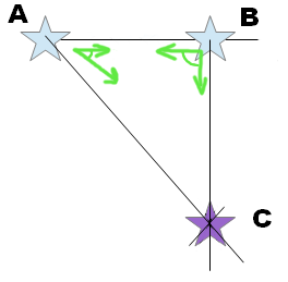
You need two places in the area to be mapped, lets call them 'A' and 'B'. You need to be able to get to both. You must be able to see A from B and B from A. This can be as simple as a school playground. 'A' could be an isolated tree, 'B' could be the center of a gate into the playground. The map-maker goes to 'A'. He/ she points one arm at 'B', and the other arm at something to be put on the map, let's say the door into the school building. We'll call it... guess what... 'C'. He notes the angle made by his arms while pointing to 'B' and the door. The correct, usual, obvious- once- you- understand- it name for this is: 'angle BAC'. (Or, you could call it 'CAB'... but that's the only other valid name. The letter 'A' must be in the middle because that is where the map-maker was standing pointing his arms, thus making the angle we have just named.)
Now the map-maker goes to 'B'. He points one arm at 'A', and, again, the other arm at the door into the school building. He again notes the angle made by his arms while pointing to the two places. This is angle ABC.
In the real world, many more angles would be involved, but these will do for now.
The map-maker then goes to a desk and gets out a piece of paper. He puts two dots on it (almost anywhere... put them in the 'wrong' places, and you'll soon see what limitations prevail.) He marks one A and the other B. He now draws a line from B to A. He then draws another line, going away from A. He draws it in the one place which makes an angle the same size as the angle his arms made when he stood at A and pointed to B and C. (The gate and the door). (Actually, there are two lines he can draw... but don't worry too much about that or you'll end up confusing yourself. If the map doesn't work, the map-maker needs to look for the 'other' angle BAC- that may be the problem.) This line can go from A to the edge of the page... as more angles are done, ways to economize on the length of line will become obvious. The map-maker must try to think about what he is doing as he goes along, to 'see' in his mind's eye the relationship between what is being drawn on the paper and what exists in the real world.
Next, the map-maker draws a line to complete the map's representation of angle ABC. The line from A to B is already drawn. A line is drawn away from B along in the right direction to make an angle the same size as ABC in the real world. Drawing most of it can be skipped. The only bit that is of interest is the bit of the line from B towards C which crosses the line from A to C which was drawn earlier. The right place on the map for C is where those lines cross! (It is the only point which is in the right direction from A AND in the right direction from B.)
So! That is how a map of three points is made. To do a more informative map, you just repeat the process again and again, taking bearings to other points from A and from B.
Earlier, we said that A and B could go almost anywhere on the map. This is true, but if you want to know the scale of the map, you need to know how far apart A and B are in the real world. Let's say they are 100 m apart. Put them 100mm apart on the map, and all over the map, 1mm will stand for 1m.
This simple... yes, it really is simple (in it's essence!)... way of making maps is particularly suited to mapping large areas of countryside. It has been the technique used for important mapping since at least 1755. Elsewhere on the web, you can see an exposition of the method in a book from 1755.
If that "sort of" made sense, PLEASE, if you haven't already met Susan and Jonathan, have a quick look at an alternative "introduction" to making maps yourself I did in April 2015. It is short, and maybe better, and the whole thing CAN be a lot of fun!
After that... here are some more, and different, "map" things...
A simple hypothetical example. And further theoretical points
A more realistic example.
Theolodite: The main tool of the trade... and how you could make one.
Data sharing initiatives. Crowd sourcing for hobbyist map making.
An account of making a map of Paris by a different technique, from some panoramic photos.
Behaviour of sun and how we navigate. Not all of the thoughts in this page are strictly to do with map making... but there is map making stuff, and more "can you figure it out" challenges, similar to things here in my "map" pages.
How they measured Mount Everest... a long time ago, from a long way away, with extraordinary accuracy.
Speaking of "crowd sourcing": If you haven't heard of OpenStreetMap or Wikimapia, they might amuse you. You won't need to measure any angles, but you will be able to extend the amazing work already done by other public spirited people, who have already done a great deal of useful work. (The OpenMap maps give me an excellent free satnav in my Android. (MapFactor's "Navigator". App and data: Free. Connection to internet NOT needed while driving, but, (I hope obviously), a GPS sensor is needed.))
Search across all my sites with the Google search button at the top of the page the link will take you to.
Or...
Search just this site without using forms,
Or... again to search just this site, use...
The search engine merely looks for the words you type, so....
*! Spell them properly !*
Don't bother with "How do I get rich?" That will merely return pages with "how", "do", "I", "get" and "rich".
I have other sites. My Google custom search button will include things from them....
One of my SheepdogGuides pages.
My site at Arunet.
To email this page's editor, Tom Boyd.... Editor's email address. Suggestions welcomed! Please cite "Aru/mm1.htm@
![]() Page has been tested for compliance with INDUSTRY (not MS-only) standards, using the free, publicly accessible validator at validator.w3.org. Mostly passes.
Page has been tested for compliance with INDUSTRY (not MS-only) standards, using the free, publicly accessible validator at validator.w3.org. Mostly passes.
AND passes...
